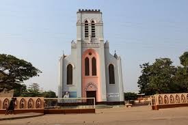
Red City of Kandi
Kandi, nicknamed the Red City for its distinctive ocre-red laterite buildings, is the crossroads of northern Benin: a bustling market, banco architecture, and a perfect launch point for W National Park.
In Kandi, in northern Benin, the Red City refers to the historic quarter and city center built from laterite—the distinctive ocre-red clay characteristic of the Sahelian landscape. Banco constructions and dusty lanes give the town a uniform hue that earned it this evocative name. Kandi is also a commercial crossroads between Benin, Niger, and Burkina Faso, making it a vibrant stop on the northern route.
What to see
Kandi's heart is best explored on foot. The central market brings together Fulani, Dendi, and Bariba traders around fabrics, spices, and livestock. Banco houses with flat roofs reflect a spare Sahelian architecture, quite different from the south. On the town's outskirts, wooded savanna stretches toward W Park, one of West Africa's great transnational reserves.
History and context
Kandi is historically tied to the Bariba kingdom of Nikki and the caravan routes that crossed northern Benin. The town became a departmental capital (Alibori) following independent Benin's administrative reforms. Its frontier location made it a point of passage and exchange between several Sahelian ethnic groups and cultures.
Highlights of a visit
The central market
Kandi's market is among the liveliest in northern Benin. On major market days, Fulani herders bring cattle and sheep. Stalls of cloth, millet, and local products paint a true picture of Sahelian commerce.
Laterite architecture
Wandering the old quarters reveals well-preserved banco houses. The red earth color suffuses everything: walls, lanes, even the dust suspended in the dry season air.
Gateway to W Park
Kandi serves as the logistical base for reaching Benin's W National Park, a UNESCO World Heritage transnational reserve. Elephants, lions, hippotragues, and buffalo are observable there, especially in the dry season.
Photography tips
Golden morning and evening light brings out the ocre tones of laterite. The market is most photogenic early, before the heat peaks. Always ask permission before photographing people—discretion is valued.
Location and access
Kandi lies in Alibori department, about 600 km north of Cotonou via National Route 2. Buses and bush taxis connect Kandi to Parakou, the north's main city. From Parakou, expect several hours depending on road conditions. Access to W Park is by track from Kandi or Malanville.
Nearby attractions
- W National Park of Benin — UNESCO transnational reserve with exceptional wildlife in the dry season.
- Malanville — border town with Niger, major regional market on the Niger River.
- Parakou — capital of northern Benin, cultural and commercial hub several hours south.
- Nikki — former seat of the Bariba kingdom, known for the Gaani festival.
Frequently asked questions
The dry season (November to April) is most pleasant for travel: tracks are passable and W Park wildlife gathers around water points. If possible, avoid the peak heat of March–April.
Yes, that's the classic pairing. Kandi offers lodging and supplies before entering the park. Plan at least two days for W Park.
Kandi is predominantly Muslim. Clothing covering shoulders and knees is recommended, especially in the market and residential neighborhoods.
Bus companies serve Kandi from Cotonou via Parakou. The journey is long—plan for a full day of travel. A rental car with driver is the most comfortable option.
Half a day suffices for the market and town. If visiting W Park, plan an overnight stay to depart early toward the reserve.
Interested in this visit?
We can include it in your personalised itinerary.